
Walk a Mishawaka Street Record Trail
A Mishawaka street directory search works best as a chain. Property records establish the land and assessed owner, not every resident. GIS confirms which lot belongs to the address. Deeds show recorded transfers, while an official voter lookup can confirm one known registrant. Historical directories help with past occupants. Each step supplies a better key for the next source.
- Normalize the full address with USPS, then search the St. Joseph County Engage portal. Save the situs address and parcel number.
- Open MACOG GIS and select the same parcel. Check street, municipal boundary, and nearby parcel context.
- Compare LowTaxInfo for tax unit, legal description, owner mailing address, and tax details. Do not call its owner line a resident list.
- Use the current owner's name, parcel, subdivision, or legal description in the Recorder's Tapestry or Laredo land index.
- For a known person, use IndianaVoters as a person-specific confirmation. For old occupants, consult the local criss-cross directory shelf.
Save the query and access date at every stage. A spelling change or map update can alter a later result. If an address fails, remove punctuation and unit data, try the base street number, and switch to the parcel number.
Search Mishawaka Parcels in Engage
The free St. Joseph County Engage assessment portal displays one search box labeled for owner, address, or property number. A parcel result can include the owner and mailing address, situs location, parcel number, value, transfers, tax context, land and improvement data, sketch, documents, map, and property card. Covered-person names or addresses may be restricted under Indiana law.
| Search key | Required | Best use | Limit |
|---|---|---|---|
| Owner | No | Find parcels tied to a known owner | Not an occupant roster |
| Address | No | Start a Mishawaka street search | Formatting may affect matches |
| Property number | No | Return to one exact parcel | Not a ZIP or deed number |
| Print / ArcGIS Print | No | Preserve a dated card or map | Portal data can change |
Tabs include Summary, Sketch, Transfer History, Sales List, Valuation List, Taxes, Land Info, Improvement Info, Neighborhood Amenities, Documents, Street View, and Forms. Transfer History is a lead. The recorded deed remains the source for a legal transfer.
Map Mishawaka Streets and Parcels
The MACOG Regional GIS Property Viewer searches St. Joseph County by address, owner name, or parcel ID. Its public guide describes highlight, zoom, print-map, and print-report controls. Mapping layers can distinguish parcel edges, street centerlines, municipal lines, zoning, subdivisions, taxing districts, precincts, easements, and flood context. These layers answer different questions and should not be treated as one boundary.
The county Assessment Neighborhood Map offers another route. Enter an address or tax ID, turn off the Taxing Neighborhood layer, select Parcel, click the lot, and choose the PARCPRC link for the annual property record card. A map selection confirms land context. It does not identify all people at that location.
Note: Print or capture the map date and active layers, since a boundary or parcel display may change after a split, annexation, or update.
Mishawaka Street Records Compared
No single official source is a complete street directory. Use the record whose legal purpose matches the question. A parcel roll is strongest for assessed ownership and land facts. A deed index is strongest for recorded transfers. A permit or code file may explain work at a site, while a dated historical directory can name an occupant.
| Record Set | Keeper | What It Shows | Access |
|---|---|---|---|
| Assessment card | County Assessor | Assessed owner, situs, value, building and land facts | Free Engage search; office counter |
| Tax record | County Auditor | Owner mailing line, tax unit, legal description, tax history | Free LowTaxInfo; Plat Room |
| GIS parcel map | MACOG / city GIS | Lots along a street and selected public layers | Free viewer; data request |
| Recorded instruments | County Recorder | Deeds, mortgages, liens, plats, easements, releases | Limited search, paid portal, subscription, public computer, mail |
| Voter confirmation | Indiana / county elections | Status and voting information for a known person | IndianaVoters; restricted file request |
| Permit or code file | City Building / Code | Work, inspection, complaint, or enforcement facts if retained | Department request or city APRA |
The parcel number is the clean bridge from assessment to maps and recorded land documents. Street names are less stable and may be formatted in several ways. Save the legal description when it appears. It can carry a search through a changed number or a record that omits the modern situs address.
Bridge Mishawaka Parcels to Deeds
The county land-record search page separates a limited free search from Tapestry for occasional use and Laredo for frequent use. Tapestry accepts first and last name, beginning and ending dates, consideration amount, document number, document type, tract, subdivision, and parcel number. Its posted cost is $8.75 per search, with image printing at $1.50 for the first page and $1.25 for each later page.
Laredo is a subscription path and reports full index and digital-image coverage from January 1992. The Recorder also offers appointment-based public computers for one-hour sessions, with no appointments from noon to 2. The office at 227 W. Jefferson Boulevard, Room 321, South Bend, can be reached at (574) 235-9525. Its weekday office hours are 8 to 4:30, with recording stopping at 4.
View the official Recorder Tapestry access page.
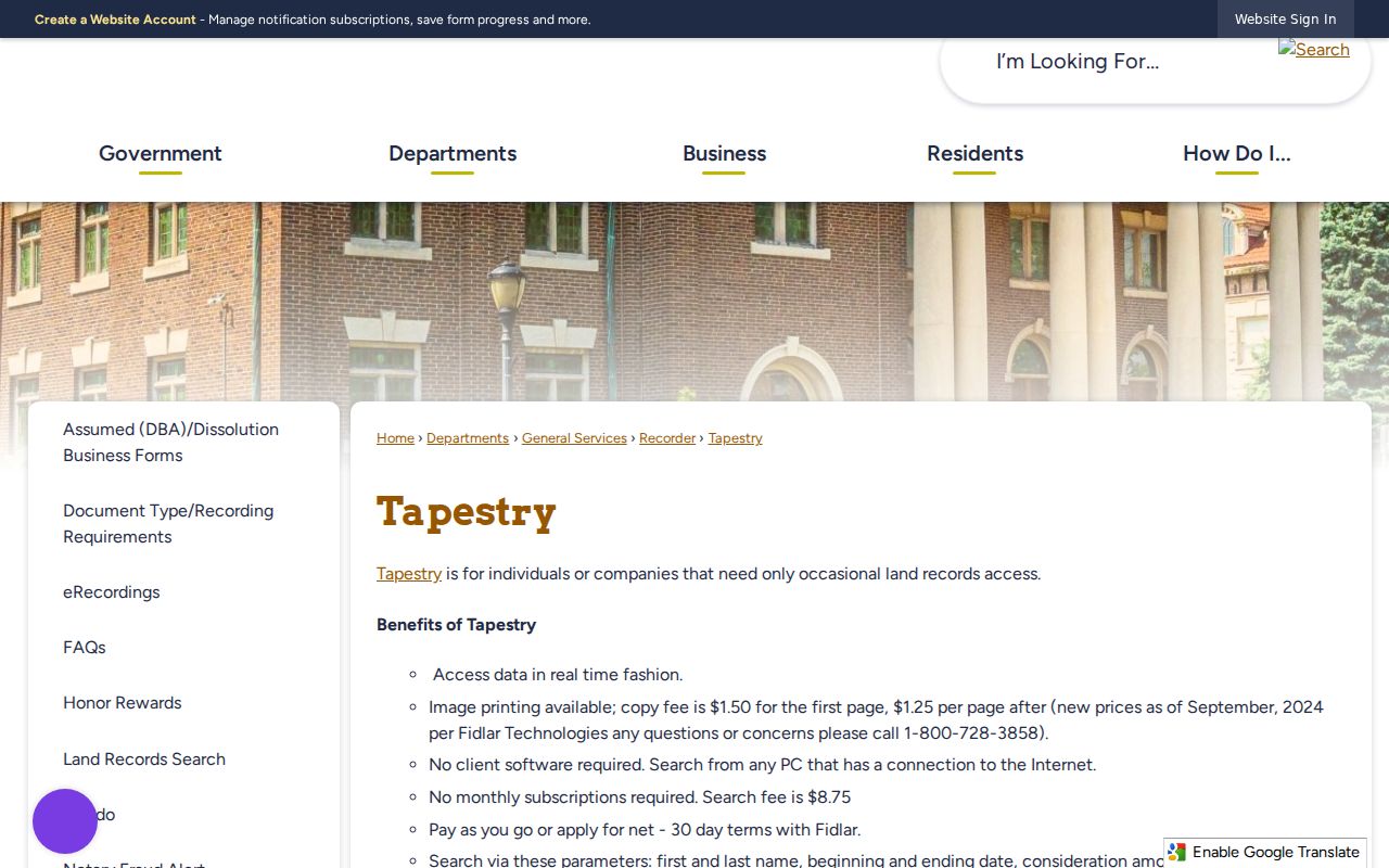
The captured page documents the paid occasional-use route; the limited search, subscription service, and office computer remain separate access channels.
Mishawaka Address Record Terms
Four terms keep a by-address search precise. They separate a street label from the land identity and from a historical occupant clue.
- Parcel
- A mapped tract of land with a county property number. One address can involve more than one parcel.
- Situs address
- The physical location assigned to land or a building, distinct from the owner's tax mailing address.
- Plat
- A recorded map that divides land into lots, blocks, streets, or easements.
- Criss-cross directory
- A historical directory arranged by street and house number so an address can lead to a listed occupant.
Three Mishawaka Property Views
Engage, LowTaxInfo, and MACOG complement one another. Engage centers the assessment card and transfer tabs. LowTaxInfo supplies tax-year, tax-unit, duplicate-number, legal-description, and payment context. MACOG adds parcel geography and public map layers. A mismatch is a reason to check timing and keys, not to choose the most convenient screen.
| Source | Best evidence | Check before relying |
|---|---|---|
| Engage | Assessment card, value, improvements, transfers | Covered-person restriction and displayed data date |
| LowTaxInfo | Tax detail, mailing owner, duplicate number, legal description | Ownership can lag by about 24 hours |
| MACOG | Parcel location and surrounding map layers | Active layer, map date, and parcel selection |
Mishawaka Permits by Street Address
The Mishawaka Building Department issues and tracks building, electrical, plumbing, HVAC, and other permits inside city limits. Its public page has a keyword document filter, but research did not locate a public address-indexed permit result system. Ask whether historical logs or inspection cards can be searched by the exact address and what years remain.
The department is at 100 Lincolnway West and lists (574) 258-1607, Monday through Friday 7:30 to 4:45. Code Enforcement takes complaints by street address or cross-street, but its complaint form is not a public case index. For an existing record that is not posted, use the Mishawaka APRA request form. Name the department, address, date range, record type, and whether inspection or copies are sought.
Note: Ask for a permit log or inspection card already held by the city, not a new summary that staff would have to create.
When a Mishawaka Address Changes
No official source reviewed provides a complete Mishawaka street-renumbering chronology. A failed modern address search therefore needs a map-and-land fallback. The 1907 Mishawaka Sanborn set contains 15 sheets with period street names, building footprints, use, materials, and hazards. State Library map lists add 1913, 1923, 1954, and other atlas or plat years.
Compare the old city directory, the matching map year, plat, centerline layer, and Recorder legal description. A lot may have been renumbered, split, annexed, combined, or cleared. Never project today's parcel outline back to an older year without evidence. Preserve both the old wording and the modern match.
The historical volumes themselves are covered more fully in the Mishawaka city directories collection.
Mishawaka Street Search Fallbacks
Online tools are only one access channel. The St. Joseph County Recorder accepts counter and mail work as well as electronic filings. A mailed document request should identify the party or name, a phone number, the record sought, return envelope and postage, and the proper fee. The office accepts guaranteed funds rather than personal checks. For pre-1992 deed work, ask specifically about deed books, microfilm, public computers, and an index search because verified online image coverage does not reach that far.
The County Auditor and Plat Room maintain parcel and owner changes that arise from deeds, parcel splits, right-of-way work, vacations, and consolidations. Email platroom@sjcindiana.gov when a current tax screen and recorded land description do not align. The Assessor's counter can help with annual cards and valuation material. A question about a certified deed or recorded plat still belongs with the Recorder.
For city-held address records, the Mishawaka APRA form asks for the department, a precise description, and whether the requester wants to inspect or copy. The county disclosure form likewise asks for the department, exact record description, and inspect-versus-copy choice. Its stated general copy line is $0.05 per page, though another lawful fee can apply. Narrow requests by street number, street name, record type, and date range. Ask where a file was transferred and what retention rule applies when the first office no longer holds it.
This fallback chain matters when a street directory result is blank. Record whether the response means not found, not held, restricted, or destroyed under a schedule. Those outcomes are not the same, and none should be rewritten as proof about who lived at the address.
Limits of a Mishawaka Street Directory
A property owner search does not name every resident, family member, guest, or renter. Utility customer data and delivery data are not a public household roster. IndianaVoters is designed to confirm a known person's registration, polling place, ballot, and related status, not to display everyone on a block. A county VRG-24 data request has disclosure and use limits, and protected voters may be withheld.
Engage also warns that covered persons can have names or addresses restricted under IC 36-1-8.5. Indiana's Address Confidentiality Program protects qualifying voter identity, address, telephone, and identifying data. A blank result means only that the information was not public or indexed in that search. It does not prove that no one lived there.
Lawful use. Use Mishawaka address records for lawful personal research. Never use a street search to stalk, harass, threaten, or expose a protected person.
A responsible result identifies the source, record date, and limit. State "assessed owner" for an assessment record, "grantee" for a deed, and "listed occupant" for an old directory. Those roles are not interchangeable.